Subsea Spool-Piece Metrology Campaigns in Indonesia

[vc_row][vc_column][vc_column_text css_animation=”bottom-to-top”]

logo_glow

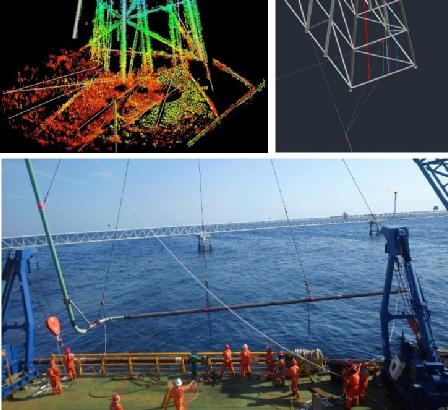
Bintang Subsea recently completed a number of subsea spool-piece metrology campaigns in Indonesia. With tights window for installation and measurements, Bintang Subsea mobilised an acoustic metrology solution for rapid installation onto construction barges in Indonesia. Working at sites crowded with existing pipelines and structures meant there was no room for error, and fast visualisation and reporting of the results in 3D was required to allow spools to be constructed offshore and installed within hours of completing the metrology measurements


f5c96b4e-b7ca-4275-88c5-55beac2352a6-medium

[/vc_column_text][/vc_column][/vc_row]

Training Services

Bintang Subsea provides specialist hydrographic consultancy services, and hydrographic survey training courses to clients worldwide. Training courses can be tailored to your specific projects needs, or software/hardware requirements.

Our trainings are designed to give participants a deep understanding and hands-on knowledge within each training curriculum. Trainings may include both operational and technical course and vary from basic to advance training depending on client’s requirement.

Bintang Subsea can provide courses and training by combining theoretical with practical session on these following areas:

  1. Survey Software Packages
  2. Multibeam Echosounder Operations
  3. Subsea Acostics, including USBL and LBL
  4. Data processing, QC and Visualization
  5. Dredging Support
Training and consultancy can equip our clients with the invaluable knowledge that will improve efficiencies on current works and also be carried on and benefit future projects

Barge & Anchor Handling Tug Positioning

Correct position for Barge and AHT’s Operations
Bintang Subsea recognizes positioning and accuracy are crucial for surveying and engineering projects, therefore we use the latest navigation equipment and software to give the client the correct position all the time.
“Maximum Performance with minimum downtime”


Whats on Star 3rd Edition

[vc_row][vc_column][vc_column_text css_animation=”appear”][real3dflipbook id=”2″][/vc_column_text][/vc_column][/vc_row][vc_row][vc_column][vc_btn title=”Download Whats on Star 3rd Edition” align=”center” css_animation=”appear” link=”url:http%3A%2F%2Fbintangsubsea.onpressidium.com%2Fwp-content%2Fuploads%2F2015%2F07%2FWhats-on-Star-3nd-Edition.pdf||” button_block=”true”][/vc_column][/vc_row]

Whats on Star 2nd Edition

[vc_row][vc_column][vc_column_text css_animation=”appear”][real3dflipbook id=”3″][/vc_column_text][/vc_column][/vc_row][vc_row][vc_column][vc_btn title=”Download Whats on Star 2nd Edition” align=”center” link=”url:http%3A%2F%2Fbintangsubsea.onpressidium.com%2Fwp-content%2Fuploads%2F2015%2F07%2FWhats-on-Star-2nd-Edition_Published.pdf||” button_block=”true”][/vc_column][/vc_row]